The Flood Planning Level Surface allows the user to produce a peak surface that is a specified amount (freeboard) above the peak water surface level in a set of results. This may be useful in defining the extent of properties that fall within a Flood Planning Level.
The user is prompted to select the layers in the project to create a Flood Planning Surface for. The user will then be prompted to specify a file to save the new surface to (non-batch mode), or have them output to the same location as the water surface file with a "-FPL" appended to the filename. The user can then enter the freeboard to apply.
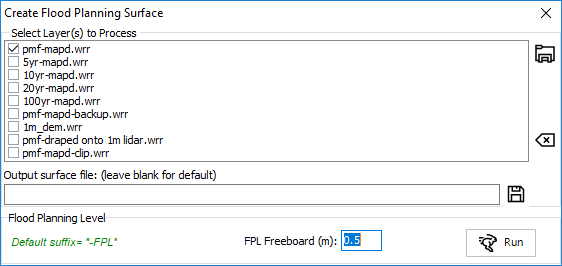
The tool will then add the freeboard to the peak water level at each node.
After running this tool, it may be worthwhile using the stretch water surface tool to automatically extend (stretch laterally) the flood planning level to its 'flood extent'.