Surface Pyramids
Extremely large grids running in infinite grid mode access surface information directly from disk each time the screen is redrawn. This process can be data intensive and display speed may be compromised when accessing information from relatively "slow" locations such as standard file networks (ie locations with high relative latency). Even smaller grids running across slow connections may benefit from building pyramids.
Building pyramids reduces the volume of information necessary to draw redraw the screen and will significantly increase display speeds for very large grids, especially when accessing datasets across a network. In fact, it is essential to build pyramids for network based surfaces accessed using infinite grid. Even local disk or SSD based datasets will see some speed improvement using pyramids.
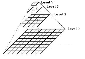
A Pyramid is a collection of layers representing the original surface at a range of successively coarser resolutions. As the screen is redrawn, the appropriate pyramid level is selected relative to the screen zoom level. After sufficient zooming, the base layer will be accessed directly.
A level 1 pyramid can also be created which resides between the surface (Level 0) and the first natural level (Level 2). This can be useful for further improving the performance of network based datasets but significantly increases the datasets storage footprint. By default, Level 1 pyramids are not created.
Pyramids will be generated for both "peaks only" and full "time series" surfaces.
Building pyramids for any surface will force that surface to be opened in infinite grid mode. Toggling between infinite grid and normal mode for standard sized datasets will require you to rename the "Ln" pyramids (refer below).
However, pyramids can only be used with waterRIDE™ grids when the grid is:
•not rotated
•not be being re-projected
Surface pyramids will be saved with the same name as the surface file with an "Ln" appended for each pyramid level. As the original grid forms Level 1 (or the base) of the pyramid, the second level of the pyramid will be labelled Surface_Name.wrr_L2, and so on.
Creating Pyramids for a dataset will increase its disk storage footprint by around 33%. If a Level 1 pyramid has been included, the pyramids will add 83% to the disk storage footprint for the layer.
Aerial Imagery
Since waterRIDE 10, pyramids (overview) are built automatically for aerial imagery if needed.
This tool is for legacy support only.