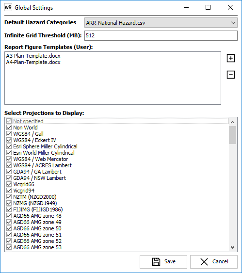
Default Hazard Categories: Allows the user to specify which hazard categories should be highlighted by default in any Hazard Definition selection boxes (refer Hazards Manager).
Infinite Grid Threshold: Allows the user to specify the threshold at which infinite grid is applied. The concept of infinite grid is to access extremely large gridded datasets directly from disk, rather than loading the grid into memory. Setting a high threshold will result in water surfaces being loaded into memory, which provides maximum performance when zooming/panning/interrogating surfaces. Setting a low threshold will mean that surfaces are read from disk, which is generally slower than in-memory datasets. For network-based datasets, infinite grid may result in slow performance. In such cases, building pyramids for each surface is strongly recommended. If pyramids are built for a surface, it will always be opened in infinite grid mode (v8.40+).
This threshold is a trade-off between performance and memory usage, and is intended for visualisation of surfaces only. Processing of gridded surfaces in "infinite grid" mode (eg creating flood extents) may cause memory issues, or may run very slowly.
The threshold is based on the size of the base grid (ie number of rows X number of columns X 4 bytes). Any water surface included in a project will use approximately 110% of its base grid size in memory, unless infinite grid is enabled. Therefore, if a large number of water surfaces are included in a project, the 3GB limit for a 32-bit waterRIDE application will be reached.
Recommended settings are as follows:
Usage
|
Recommended Threshold Setting (MB) |
General usage (default)
|
512 |
UK Surface Water Datasets
|
256 |
The Infinite Grid Threshold can be set in a number of locations. The order of determining the infinite grid to use for a given waterRIDE™ instance is as follows:
•Default value of 512MB
•If specified in the Application INI file, override above (this setting must be manually made in the application ini file: eg MaxGridMemorySize=700000000 in the [APPLICATION] section
•If specified in User INI file, override above (this setting is controlled using the File->Preferences menu item)
Allows the user to specify which projections are displayed by default in any "projections" drop down list. Where an existing project contains layers or views in a projection that is not visible, those projections will be automatically added to any "projections" drop down list.
Plot Templates:
Formatted Microsoft Word documents can be used as templates for preparing figures. Local user templates can be added/removed from the templates list using the add/remove buttons. Any configured Enterprise templates will take precedence over locally installed templates. Details on using templates and special formatting requirements can be found here.
Select Projections to Display: Select those projections you wish to display by ticking each box. By default, all projections are visible.
Note: GDA2020 was introduced with 10.0.9. If you have previously selected a subset of projections it will not appear in your projections list. Ensure that the relevant GDA2020 projections are selected in the list.