The GIS Tools group provides a range of tools for manipulating vector GIS layers
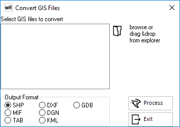
Convert Layer
Provides a utility to convert GIS files from one format to another. Select the files to convert and the desired output format.
Clip Layers
Provides two tools for clipping GIS layers:
Clip Layers to View
This option allows the user to clip all GIS layers to the current view extents. waterRIDE™ will then export the files as a new GIS file, with the suffix "-clipped" in the filename, in the original GIS file's folder location. It should be noted that only polygons of the layers completely situated within the view extents will be exported to the clipped GIS file.
Clip GIS file to Polygon
This option allows the user to clip an external GIS file using any polygon in the active layer. This allows for more complex clipping of a GIS layer than can be afforded by the "Clip Layers to View" option.
Once an active polygon has been selected, the Select GIS layer to Clip window is displayed. From here, the GIS file to clip is selected, and then clipped to the polygon extents. It is important to ensure that both GIS layers are in the same projection.
waterRIDE™ will then export the files as a new GIS file, with the suffix "-clipped" in the filename, in the original GIS file's folder location.
Convert to View Projection
This option converts a GIS layer from one projection to the current view projection. This may be useful to avoid "on the fly" reprojection of layers which can slow down performance slightly for large vector GIS layers.
Geometry Tools
Provides three tools for working with GIS layers:
Mark Poly Crossovers
Creates a GIS file of points showing the location of polygon intersections for the active GIS layer.
Break Complex Poly
Breaks (or explodes) all complex polygons in a layer into simple, single polygons
Make Complex Poly
Combines all simple polygons in a layer into a single, complex polygon
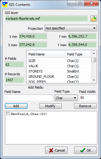
Attribute Field Data
Add/Delete Fields and Update Column Names
Allows the user to add/delete fields to an existing GIS layer, or to change an existing layer's field names. Load the layer, enter the field name, type and width (if applicable). Click OK to save the file.
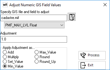
Adjust Numeric Field Data
Allows the user to adjust numeric field values in a GIS layer using an adjustment "operator". Select the GIS layer to update, the relevant field to adjust, the adjustment value, and finally how to apply the adjustment:
- Add - adds adjustment value to the field value
- Multiply - multiplies the field value by adjustment value
- Set Value - sets the field value to the adjustment value
- Min Value - if the field value is less than the adjustment value, sets the field value to the adjustment value
- Max Value - if the field value is greater than the adjustment value, sets the field value to the adjustment value
- Round - rounds the value to the specified number of decimal places
- Round Up - rounds the value up to the specified number of decimal places
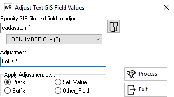
Adjust Text Field Data
Allows the user to adjust textual field values in a GIS layer using an adjustment "operator". Select the GIS layer to update, the relevant field to adjust, the adjustment value, and finally how to apply the adjustment:
- Prefix - adds adjustment before the current value in the field
- Suffix - adds adjustment after the current value in the field
- Set Value - sets the field value to the adjustment value
- Other Field - sets the field value to the same value in another field