Determine Probability of Inundation
The Determine Probability of Inundation tool determines the probability (or ARI) at which a level contained in a field value of a GIS layer is reached at the peak of a flood. For example, the GIS layer may contain properties with floor levels, or evacuation routes with the low point elevation, or critical infrastructure with a key level.
If you wish to determine the probability at which all parts of the floodplain are first inundated (ie a surface), use the Statistics tool.
To calculate the probabilities, interpolation between surfaces of different magnitudes is carried out. Consequently, the algorithm assumes a montonically varying magnitude between probabilities for any given location (ie the water level for the 100yr flood is greater than the 50yr flood and less than the 200yr flood). Care should be taken when using the tool on surfaces that do not display such behaviour.
All layers used in the analysis must be in the current project.
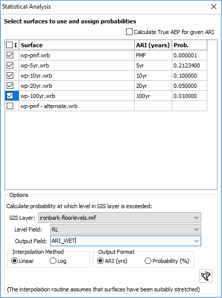
Assign Probabilities to Surfaces: Select the surfaces to include in the analysis and ensure that a probability is assigned to each surface. The probability will be used to interpolate the ARI at which the specified level is reached. The probability will be stored in the surfaces cfg/cfg2 configuration files.
GIS Layer: Specify the GIS layer containing the locations at which to determine the ARI at which the level specified in the field is reached. The resulting probability will be stored in the output field.
Interpolation Method: Specify whether to use log or linear interpolation.
Output Format: Specify ARI or probability
Note as this tool uses interpolation, it assumes all surfaces have been stretched to the next higher surface in the library (eg 1 in 10 stretched to the 1 in 20, 1 in 20 stretched to the 1 in 50 etc).