From v7 onwards, waterRIDE™ supports database-based GIS layers.
waterRIDE™ uses the GDAL/OGR open spatial libraries to provide support for these types of layers. Further information on this library can be found at www.gdal.org
To ensure manageable loads on database servers, these layers are treated as read-only within waterRIDE™. Should you wish to edit, or carry out heavy processing on these layers, you should collect them (convert into a shapefile), process/manipulate the shapefile, and then merge any changes back into the source database layer.
It may be worthwhile experimenting with the performance of database-based GIS layers against local-file based layers to achieve optimum performance, as local layers tend to be faster. You should also ensure that a spatial index has been created for each layer in the database you intend to access.
Support is implemented through a *.DBvec file. This file is a Windows ini file containing connection information to a single layer within the database. You connect each layer in a database using a DBvec files for each layer.
To configure a DBvec file:
1.Select the database type from the dropdown list. This is a dynamic list and will vary depending on the databases available on your system.
2.Select the file or enter relevant database server details
3.Click Connect To Database
4.If successful, select the layer to connect to from the Layer dropdown list. Database layers often contain multiple layers. However, a single DBvec file will support only one layer. If multiple layers are to be used, a DBvec file should be created for each layer.
5.Save the DBvec file to your system. This layer can be loaded into any waterRIDE™ project as a Vector GIS Layer.
Each vector type has different configuration settings:
Vector (ESRI File Geodatabase)
Important Note: If your GDB layer displays when fully zoomed out but disappears as you zoom-in, the spatial index files are corrupted/not supported by GDAL. waterRIDE will automatically try and delete these index files if encountered. A warning message will be displayed if unsuccessful.
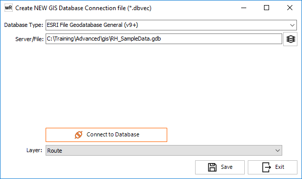
An ESRI file geodatabase is a folder with the name of the database followed by a ".gdb". Select this *.gdb folder to connect to the database.
Vector (ESRI Personal Geodatabase)
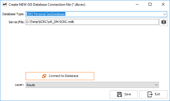
An ESRI Personal geodatabase is a Micorosft Access Database file (*.mdb) Select any file within this folder. Specify the relevant mdb file to use.
Vector (Microsoft SQL Spatial - MSSQL)
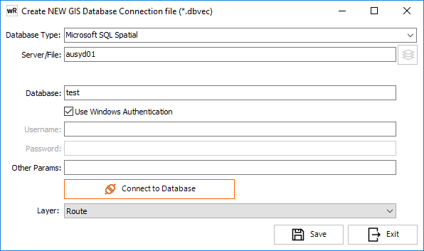
To connect to a SQLServer spatial database, the following fields must be completed:
Server/File: Address/name of the Server
Database: the database name to access
Use Windows Authentication: if used, username and passwords do not need to be stored for the layer. If a username and password is to be used, enter them in the relevant boxes.
Other Params: A Standard SQLServer ODBC Driver Connection String is used to connect to the database. As such, if parameters in addition to those specified above are required for your particular configuration, these can be entered as a colon (;) separated list using standard keywords. For example, the following additional parameters will invoke self signing encryption, if setup on the server:
Encrypt=Yes;Trusted_Connection=Yes
Layer: Select the layer to connect to. If the layer you wish to connect to does not appear in the list (and is a spatial layer), you can enter it directly into the dropdown. Note that spelling must be exact.
Note that SQL Spatial layers should have a native Spatial Index built using MSSQL for optimum performance.
Vector (Oracle Spatial)
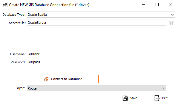
Server/File: Address/name of the Server
Username: Username to connect with
Password: Password to connect with
Layer: Select the layer to connect to. If the layer you wish to connect to does not appear in the list (and is a spatial layer), you can enter it directly into the dropdown. Note that spelling must be exact.