Filtering a Water Surface
Similarly to filtering a GIS layer, the Filter Tab on the display styles form can be used to show only those areas of the model where a certain filter condition is true. Clicking on the ‘Filter’ tab will bring up a range of options which allows the user to specify the filter conditions.
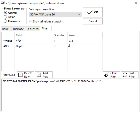
Water surfaces can be filtered using their hydraulic parameters. A filter functions in a similar manner to a database SQL query. The user can enter or edit the condition/s of the filter by editing the filter grid. A filter is of the general format "SELECT * FROM {water surface filename} WHERE {parameter} {operator} {filter value}". The filter will apply to the layer in the current view only. Any other views containing the layer will not automatically have the same filter.
The first column in the filter grid allows multiple constraints to be identified. The first row in the table is "WHERE" which specifies the first condition of the filter. For each subsequent conditions (additional rows) in the same filter, the options for this field are the boolean operators "AND" or "OR". The "AND" condition specifies that only those parts of the surface where both conditions are true will be displayed, whereas the "OR" condition specifies those parts of the network where either of the conditions are true will be displayed.
The second column in the filter grid is the hydraulic parameter which will be used to filter the surface by. The user can choose the parameter via the drop down box in the grid.
The third column specifies the operator that will be used to filter the water surface layer. The operators available for the user to choose, include: "<", "<=", ">", ">=", and "<>" for numerical data:
> hydraulic parameter greater than the filter value.
>= hydraulic parameter greater than or equal to the filter value.
< hydraulic parameter less than the filter value.
<= hydraulic parameter less than or equal to the filter value.
= hydraulic parameter equal to filter value
<> hydraulic parameter not equal to filter value
The final field specifies the filter value used to filter the hydraulic parameter. Any value can be inserted into this field and used to filter the data.
The "Filter SQL" data box displays all the filter conditions which apply to the current layer, in the current view.
The create filter button checks the conditions of the filter added by the user, and then stores the filter conditions which will be used with that layer and view into a "*.vmsql" file, with the same name as the project file. In order to use a filter the create filter button has to be clicked so that the filter can be stored.
The clear filter button deletes the filter conditions allowing the user to either implement a new filter, or work with the unfiltered data.
When combined with the GIS-Flood Integration tool, some powerful filtering can be setup.
(Also refer to Parameter Queries*)
Filtering TIN Water Surfaces (*.wrb)
As TIN water surface are continuous, filtering cannot be strictly applied. When filtering a wrb file, the centroid of each triangle is used to determine whether that triangle should be displayed. This essentially treats the continuous surface as a discrete, triangle-based surface, in the same way that finite volume models work.