Tagging a property as flood affected involve processing a GIS layer of property spatial extents (eg land parcels or building footprints) against a range of flood surfaces. A criteria is setup that must be met for the property to be tagged as flood affected. The tagging is then saved to the GIS layer in a new (or existing) field.
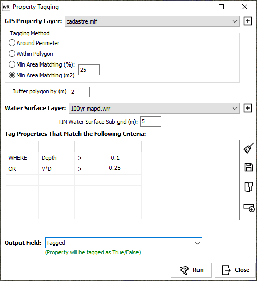
GIS Property Layer: Specify the GIS layer containing the property spatial information against which to run the criteria. Generally, this will be a GIS layer of polygons (eg land parcels or building footprints).
Tagging Method: Select the method to use to analyse the property polygon against the water surface layer:
Around Perimeter: Will sample the water surface along the perimeter of the polygon
Within Polygon: Will sample the water surface at all points within the polygon.
Min Area Matching (%): Will sample the water surface at all points within the polygon to determine the percentage (area-wise) that match the criteria. Enter the minimum threshold (%) into the edit box.
Min Area Matching (m2): Will sample the water surface at all points within the polygon to determine the absolute area (using cell area) that match the criteria. Enter the minimum threshold (in square metres) into the edit box.
Buffer Polygon by (m): Allows the property polygon to buffered by the specified distance. This can be useful if using finite volume/difference flood models that have a hard wet/dry edge and the buildings were removed from the model setup (ie there are no water levels against the property). Buffering by the equivalent of 1 cell will query the flood surface immediately adjacent to the property.
Water Surface Layer: Specify the water surface layer to query against. If a TIN water surface (*.wrb) is specified, enter the sub-grid on which to sample the surface within each property. If a gridded surface (*.wrr) is used, the grid cell size is used.
Tag Properties That Match the Following Criteria: Enter the hydraulic criteria to query the property polygons against. This is a Boolean query and the full time series (if available) will be used to determine if the criteria is met at any timestep, for each model (or sample sub-grid) cell.
Criteria can be saved by clicking the Save ![]() button. Previously saved queries can be loaded by clicking the Load
button. Previously saved queries can be loaded by clicking the Load ![]() button. Queries created using the Flood Parameter Queries tool can also be loaded.
button. Queries created using the Flood Parameter Queries tool can also be loaded.
Existing criteria can be cleared by clicking the Clear Query button ![]() .
.
Click the Add rows ![]() button to add more rows to the grid.
button to add more rows to the grid.
Output Field: Select/Enter the field to save the tagging to, in the GIS property layer.
![]() Run the tagging process.
Run the tagging process.