The Environment Agency Property Counts provide a means of replicating the the Environment Agency (UK) approach to tagging properties as "flood affected" from surface water, using any range of criteria and surface water datasets. Once tagged, property counts can be carried out, as well as using the tagged properties to calculate flood damages.
There are two parts to completing the property counts:
1) Calculating the wetted perimeter
2) Running the property counts
The datasets required to use the tools are:
•Ordinance Survey MasterMap (OSM) - a GIS layer of boundaries and building footprint polygons. A building footprints layer can also be used.
•Surface Water Surfaces - waterRIDE™ surfaces created from the uFMfSW datasets or other surface water modelling.
Optionally, you can also specify:
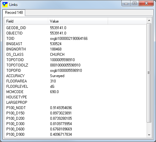
•National Receptor Database (NRD) - a GIS layer of points providing information on the dwellings encompassed within each OSM footprint. These are frequently multiple, coincident points. if specified, waterRIDE will use the MasterMap
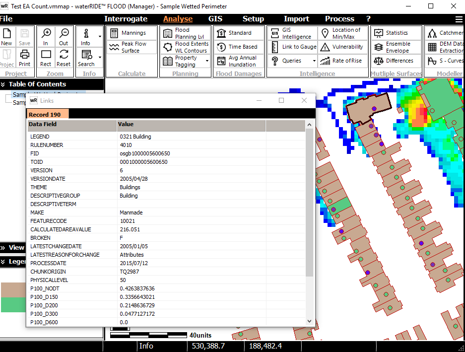
Example Ordinance Survey MasterMap (filtered using "THEME = Buildings") dataset

Example National Receptor Dataset
Calculating the Wetted Perimeter
This tool will implement the UK Environment Agency approach for determining the wetted perimeter for all polygons in a GIS layer. In summary, the EA approach involves buffering each building polygon and determining the percentage of the "exposed" perimeter (ie excluding any shared walls) that intersects with the surface water depth surface above the specified tolerance. Information on the approach can be found in EA's website.
The wetted perimeters will be stored in both the OSM and NRD (if used) GIS layers.
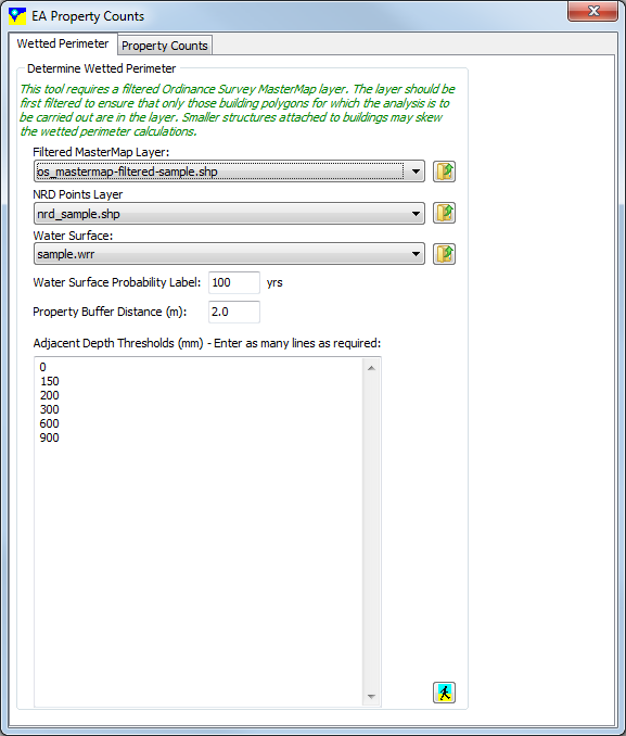
1) Select (or load) the MasterMap layer containing the building footprints you wish to include in the analysis. As this layer contains other boundaries it must often be filtered prior to analysis to ensure it contains only those footprints that are relevant to the calculations (eg filtering using "THEME = Buildings").
2) Select (or load) the NRD points layer. Set this to "< DO NOT USE>" to only carry out a wetted perimeter analysis on the supplied building footprints layer.
3) Select (or load) the water surface layer.
4) For the selected water surface, enter its ARI. This value will be used in the labelling of output fields using the EA convention.
5) Enter the distance to buffer the building footprints by. This defaults to 2m.
6) Enter as many minimum depth thresholds as required, starting a new line for each threshold.
After running the tool, the relevant wetted perimeters will be stored in fields in both the OSM and NRD GIS layers. The field names follow the EA convention. Outputs from the above example are provided below:
The property counts tool will determine the number of properties that are considered "flood affected" for the given wetted perimeter threshold(s).
Property counts can be carried out in two ways:
•Simple property counts - carries out multiple counts using a matrix of single wetted perimeter thresholds to quickly determine property counts for each depth threshold/wetted perimeter combination
•Multi-criteria property count - carries out a single property count across multiple threshold criteria (eg count a property if the wetted perimeter for a 0mm depth threshold is > 50% or if the wetted perimeter for a 600mm depth threshold is > 10%)
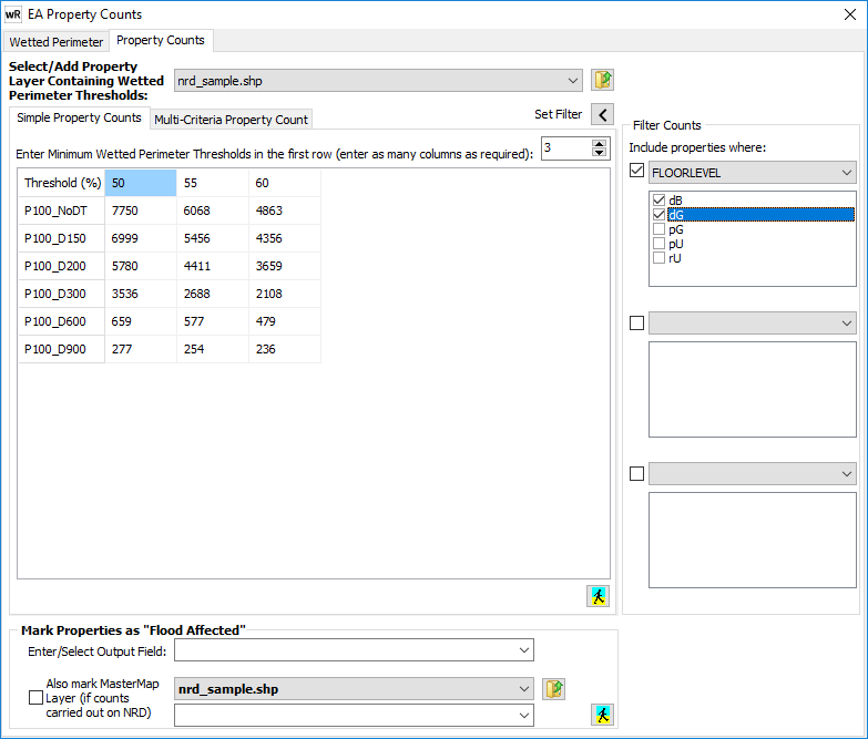
Select the "Simple Property Counts" tab.
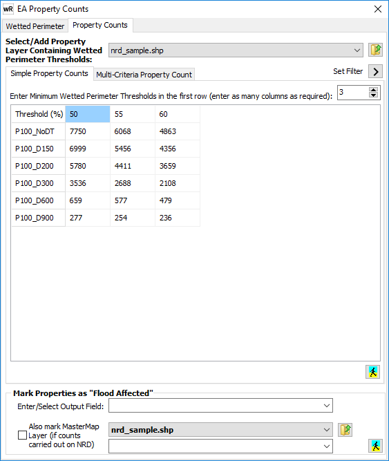
1) Select (or open) the property layer (NRD) containing the wetted perimeter thresholds. Once selected, the tool will automatically add rows to the matrix corresponding to the wetted perimeter fields found in the layer. Note that the EA naming convention has been assumed.
2) Enter as many wetted perimeter thresholds as necessary along the first row of the matrix (one per column). Adjust the number of columns using the up/down button.
3) Run the tool (![]() ). After execution, the matrix will be populated with all property counts, as above.
). After execution, the matrix will be populated with all property counts, as above.
4) The Set Filter button (![]() ) can be used to enter up to three AND filtering criteria on the NRD dataset. In the example below, property counts have been executed on the same NRD dataset as the "no filtering" example except that only properties where the FLOORLEVEL field is equal to "dB" or "dG" (definite basement or definite ground).
) can be used to enter up to three AND filtering criteria on the NRD dataset. In the example below, property counts have been executed on the same NRD dataset as the "no filtering" example except that only properties where the FLOORLEVEL field is equal to "dB" or "dG" (definite basement or definite ground).
5) Once the tool has been executed, each property can be marked as "flood affected" by first selecting the criteria in the matrix to use, then selecting (or entering) a field in the NRD GIS layer in which to store a TRUE/FALSE value corresponding to the selected criteria (cell) in the matrix. This may be used in any flood damages calculations. During this process, the OSM GIS layer can also be tagged by selecting the tick box and entering the relevant field. A simple spatial join between the "marked" NRD dataset and the OSM dataset is used.
Select the "Multi-Criteria Counts" tab.
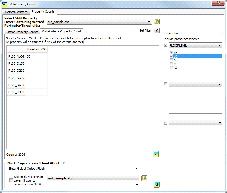
1) Similarly to the simple property counts, select (or open) the property layer (NRD) containing the wetted perimeter thresholds. Once selected, the tool will automatically add rows to the matrix corresponding to the wetted perimeter fields found in the layer. Note that the EA naming convention has been assumed.
2) Enter relevant depth threshold into the table. Only those with a valid integer value will be used in the counts. In the above example, two criteria are used in an OR query: Count a property where either the No Depth threshold wetted perimeter is > 50%, or the 600mm depth threshold wetted perimeter is > 10%.
3) Run the tool (![]() ). After execution, the single property count value is displayed under then table.
). After execution, the single property count value is displayed under then table.
4) Similarly to the simple property counts, the Set Filter button (![]() ) can be used to enter up to three AND filtering criteria on the NRD dataset. In the example above, property counts have been executed on the same NRD dataset as the "no filtering" example except that only properties where the FLOORLEVEL field is equal to "dB" or "dG" (definite basement or definite ground).
) can be used to enter up to three AND filtering criteria on the NRD dataset. In the example above, property counts have been executed on the same NRD dataset as the "no filtering" example except that only properties where the FLOORLEVEL field is equal to "dB" or "dG" (definite basement or definite ground).
5) Once the tool has been executed, each property can be marked as "flood affected" by first selecting the criteria in the matrix to use, then selecting (or entering) a field in the NRD GIS layer in which to store a TRUE/FALSE value corresponding to the selected criteria (cell) in the matrix. This may be used in any flood damages calculations. During this process, the OSM GIS layer can also be tagged by selecting the tick box and entering the relevant field. A simple spatial join between the "marked" NRD dataset and the OSM dataset is used.