A RUBICON conversion requires a number of files that are created as part of the RUBICON modelling process.
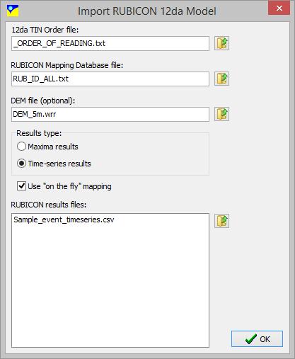
12da TIN Order File:
This file specifies the 12D TIN files that form the basis of the 2D framework onto which the 1D RUBICON results are mapped. This file is a text (*.txt) file with a numbered list of 12D TIN files (*.12da format) to use for the framework. An example is provided below:
1. 130925TINRUBID.12da
2. tin_rub_us_penrith2.12da
3. tin_m11_cattai_trib.12da
4. tin_m11_southck_trib.12da
5. tin_rub3_ds_sackville.12da
6. tin_rub1_us_penrith.12da
7. 130909TINRUBID.12da
RUBICON Mapping Database File:
This file specifies the link between the text based RUBICON outputs and the relevant 12D TIN nodes. Each 12D TIN node is identified by its "Z-value". The file format allows linear interpolation of TIN nodes that lie between two cross sections. Thism is controlled by a weighting factor to the upstream cross section. An example is provided below:
1000 1WB1 WARRADAM n/a n/a 1.00 Y 1000 0.000 0.000
1001 1WB6 WARRARIV n/a n/a 1.00 Y 1001 0.000 0.000
1002 1WB9 JUNCTION2 n/a n/a 1.00 Y 1002 0.000 0.000
1003 22WB1 WALLACIAW n/a n/a 1.00 Y 1003 0.000 0.000
1004 1WB10 JUNCTION3 1WB12 ERSKINECK 0.60 N 1004 0.000 0.000
A description of each Row follows:
Column1: 12D Node ID
Column2: not used
Column3: Upstream X-section ID
Column4: not used
Column5: Downstream X-section ID
Column6: Ratio to upstream X-section
Column7: not used
Column8: not used
Column9: not used
Column10: not used
DEM File:
waterRIDE™ surface file containing TERRAIN onto which the 1D surface will be mapped.
Results Type:
Specify the type of results that are contained in the result files: peak or time-series.
Use "On-The-Fly" Mapping:
If time-series results are specified, "on-the-fly" mapping will result in a significantly smaller file size. This is achieved by dynamically "floating" the RUBICON TIN (*.wrb) over the gridded DEM (*.wrr), rather than actually mapping every timestep. However, as every timestep must be mapped as it is displayed, performance using very large TIN's will be slower.
RUBICON Results Files:
Specify the RUBICON CSV results files to use in the conversion. Example output files are provided below:
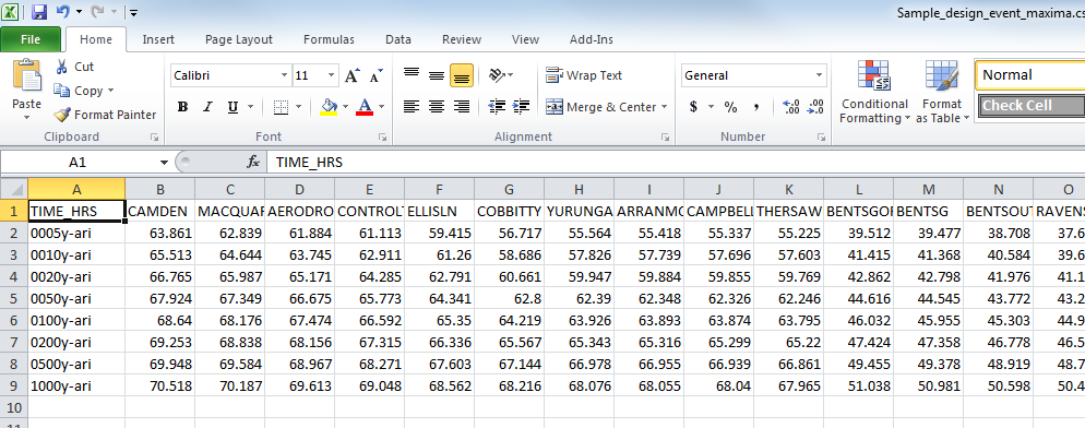
Peaks Outputs - Each row contains the peak water levels for a model. The first column contains the run ID, followed by the peak water surface value for each X-section ID:
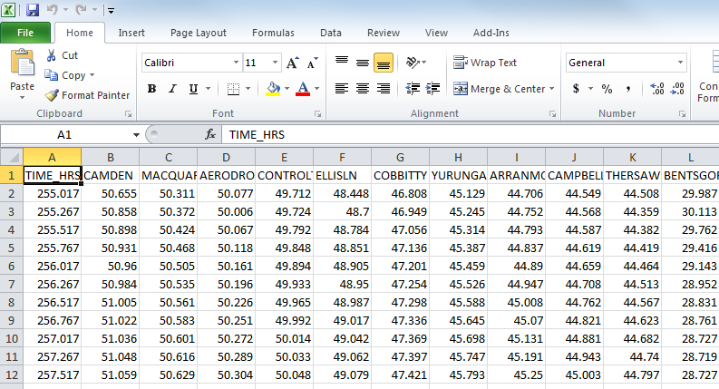
Time-Series Outputs - Each row contains water levels for each X-section for a particular timestep (in hours).
Output files will be either be the same name as the time series results file(s), or the run ID's in a peaks results set. Conversions can be batched.