Tools common to all waterRIDE access modes, and across all views appear above the NAVBAR.
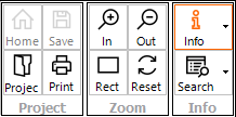
The common tools provide access to:
•Project Tools - tools for loading and saving the current project, printing the current view, and opening the Master Project (home project)
•Zoom - tools for navigating the map window including zooming in/out and resetting the to default view state (zoom extent, layer settings etc).
•Info - tools for interrogating information inside the active layer(s)![]() , as well as tools for searching and finding objects in the map window
, as well as tools for searching and finding objects in the map window ![]() .
.
![]() Open the Master Project (home project) if configured.
Open the Master Project (home project) if configured.
![]() Open an existing waterRIDE™ project via the Quick Start Dashboard.
Open an existing waterRIDE™ project via the Quick Start Dashboard.
![]() Save the project file (also CTRL+S).
Save the project file (also CTRL+S).
The zoom tools provide access to zooming specific areas of the screen. The most common form of zooming is to just scroll your mouse wheel (or pinch zoom on a touch screen). Scrolling forward (away from you) will zoom in. Scrolling backward (towards you). This is common behaviour for many spatial applications.
However, if high accuracy is needed, the specific zoom tools may help:
![]() Provide a rectangle indicating the extent that will be zoomed to when clicking the left mouse button. The size of the rectangle can be adjusted by scrolling the mouse wheel.
Provide a rectangle indicating the extent that will be zoomed to when clicking the left mouse button. The size of the rectangle can be adjusted by scrolling the mouse wheel.
![]() Allows you to zoom by clicking an dragging a rectangle. Left click on one corner of desired window and then hold and drag to the desired extent.
Allows you to zoom by clicking an dragging a rectangle. Left click on one corner of desired window and then hold and drag to the desired extent.
![]() Resets the current view to its default state (zoom extent and layer settings/visibility etc).
Resets the current view to its default state (zoom extent and layer settings/visibility etc).
The zoom tools work in concert with the Zoom Lock ![]() tool when changing views.
tool when changing views.
Background Imagery Toggling (Image Toggle)
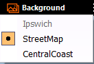 If available, the Background button allows the user to toggle the base imagery by selecting a layer from the list. If a layer is not available (such as an internet image server being down), the layer will be greyed out. Note that some background image layers may require reprojection of other data layers which may be slower than images layers in the same projection as the data layers.