With TUFLOW conversions, you have the option of running an automatic or manual conversion, as well as converting pipe flow outputs using the raw model results. The batch conversion can be used to batch convert many model results, and assumes that the *.2dm and results (*h.dat (or*d.dat) and *v.dat, OR *.xmdf) all have the same file name prefix. The single conversion allows you to specify each file individually.
Note that TUFLOW Classic traditionally outputs its 2D results on a TIN framework (which would translate to a *.wrb waterRIDE™ file), with water levels and velocities provided at cell corners. waterRIDE™ has the option to export these results as a grid file (*.wrr waterRIDE™ file), being the same as the model grid framework (new to waterRIDE 10), or as a grid file that will stretch the water surface using corner values (this is the classic waterRIDE conversion approach). Selecting TIN (*.wrb) will provide the same output format as pre v7.20 versions of waterRIDE™ FLOOD Manager. Selecting Stretch Grid will provide the same output as v8.XX versions.
Also new to waterRIDE 10 is the ability to convert a peaks only file using the peak values that are stored in the TUFLOW raw results files. This is in addition to converting the peak GIS grids exported from TUFLOW (*.asc/*.grd). Release 10.0.25 and higher also supports the ability to detect the hazards used in the TUFLOW output and automatically convert using these hazards (for peaks).
A further option with more recent TUFLOW versions is to specify direct output of waterRIDE™ files when the TUFLOW model is run.
In summary, you can convert TUFLOW results in a number of ways:
•Raw model results - single run - full time series and/or TUFLOW peaks
•Raw model results - batch mode - full time series and/or TUFLOW peaks
•Peak GIS Grids - single run or batch mode
•Pipe raw results - CSV and GIS outputs
Conversion of a Single Results Set (Raw Model Results)
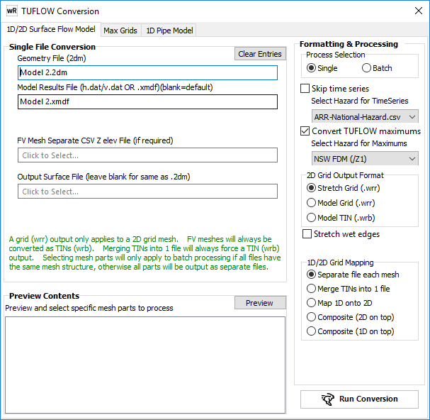
Geometry Files (*.2dm) - The model network file.
Model Results File: Locate one of the "dat" outputs (*h.dat or *d.dat or *v.dat) or the XMDF file. waterRIDE will attempt to locate these files automatically.
Output Surface File: Specify the output file or leave blank to use the same name as the network file.
Skip Time series: Do not convert the time series data in the TUFLOW output files
Convert TUFLOW maximums: Convert the maximums in the TUFLOW results (99999 timestep) to a peaks only waterRIDE file (denoted "-max'). You must specify the hazards category used in the TUFLOW modelling (waterRIDE will attempt to detect this for you assuming your Zn files are available).
Stretch wet edges: where waterRIDE detects a "wet edge" (ie glass wall), it will automatically stretch this water level out one cell to find the true flood extent.
2D Output Format: Specify whether any 2D domains should be output as:
- Stretch grid (.wrr) - the classic waterRIDE conversion which uses the cell corners as cell centroids to provide a smoother surface (especially in shallow flow areas)
- Model grid (.wrr) - as per the TUFLOW model output. This approach honours the TUFLOW "element status" flags and will produce the same output as the TUFLOW GIS tools
- Model TIN's (.wrb) - as per the TUFLOW output TIN
1D/2D Grid Mapping : Specify how waterRIDE™ should manage merging of any 1D and 2D parts of the model.
Separate file each mesh: No merging. 1D and 2D networks will be exported separately
Merge TINs into 1 file: Merge any TINs into a single file. This is the "legacy" approach to TUFLOW conversion in waterRIDE™.
Map 1D onto 2D: Output the 2D part as a grid file (*.wrr) and map the TIN based 1D portion into the 2D grid. This is the recommended option for display speed or large models, as grids are significantly faster. Note that calculating flow from any mapped 1D outputs may not be correct. If calculation of flows in the 1D portion of the network are important, then a Composite file should be used.
Composite (2D on top): Create a waterRIDE™ composite file (*.wrc) with the 2D network on top.
Composite (1D on top): Create a waterRIDE™ composite file (*.wrc) with the 1D network on top.
Update 2D Terrain From 1D for: Allows the user to control how the elevation of any cells in the 2D network underneath the 1D network will be updated using terrain values from the 1D network. Terrain values will be updated as follows:
NULL Cells: Only those cells in 2D domain that have a NULL terrain value (DELVAL) will have their terrain value updated. This is the default.
ALL Cells: All cells in 2D domain will have their terrain value updated
NULL Cells: No 2D cells will have their terrain value changed
Preview Contents: Allows selected parts of the network to be converted if MESHPARTS were used in the model setup. Simply select those meshparts you wish to convert.
During conversion, the default timestep will be determined from the model results and can be modified by the user if required. Enter an integer value to specify every "nth" step to be saved.
Batch Conversion of Results Sets (Raw Model Results)
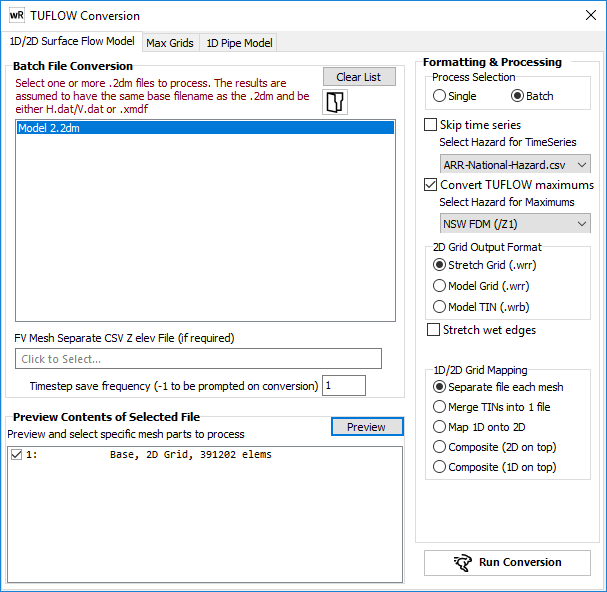
*.2dm Network Files - Locate the network file for each TUFLOW run to be converted. results files are located automatically by assuming the same base file name as the *.2dm file with either the "dat" extensions (*h.dat or *d.dat or *v.dat) or an XMDF file. Files will be saved with the same name as the network file, expect with a waterRIDE™ extension.
Timestep Save Frequency: Enter an integer value to specify every "nth" step to be saved. Defaults to 1 (every timestep).
Skip Time series: Do not convert the time series data in the TUFLOW output files. This will save time if you are only interested in the model peaks.
Convert TUFLOW maximums: Convert the maximums in the TUFLOW results (99999 timestep) to a peaks only waterRIDE file (denoted "-max'). You must specify the hazards category used in the TUFLOW modelling (waterRIDE will attempt to detect this for you assuming your Zn files are available).
Stretch wet edges: where waterRIDE detects a "wet edge" (ie glass wall), it will automatically stretch this water level out one cell to find the true flood extent.
2D Output Format: Specify whether any 2D domains should be output as:
- Stretch grid (.wrr) - the classic waterRIDE conversion which uses the cell corners as cell centroids to provide a smoother surface (especially in shallow flow areas)
- Model grid (.wrr) - as per the TUFLOW model output. This approach honours the TUFLOW "element status" flags and will produce the same output as the TUFLOW GIS tools
- Model TIN's (.wrb) - as per the TUFLOW output TIN
1D/2D Grid Mapping : Specify how waterRIDE™ should manage merging of any 1D and 2D parts of the model.
Separate file each mesh: No merging. 1D and 2D networks will be exported separately
Merge TINs into 1 file: Merge any TINs into a single file. This is the "legacy" approach to TUFLOW conversion in waterRIDE™.
Map 1D onto 2D: Output the 2D part as a grid file (*.wrr) and map the TIN based 1D portion into the 2D grid. This is the recommended option for display speed or large models, as grids are significantly faster. Note that calculating flow from any mapped 1D outputs may not be correct. If calculation of flows in the 1D portion of the network are important, then a Composite file should be used.
Composite (2D on top): Create a waterRIDE™ composite file (*.wrc) with the 2D network on top.
Composite (1D on top): Create a waterRIDE™ composite file (*.wrc) with the 1D network on top.
Update 2D Terrain From 1D for: Allows the user to control how the elevation of any cells in the 2D network underneath the 1D network will be updated using terrain values from the 1D network. Terrain values will be updated as follows:
NULL Cells: Only those cells in 2D domain that have a NULL terrain value (DELVAL) will have their terrain value updated. This is the default.
ALL Cells: All cells in 2D domain will have their terrain value updated
NULL Cells: No 2D cells will have their terrain value changed
Preview Contents: Allows selected parts of the network to be converted if MESHPARTS were used in the model setup. If this option is selected, each model is assumed to have the same MESHPARTS structure.
Note that in most TUFLOW Classic models, a 10.0m adjustment to terrain levels in the 1D model network is made by TUFLOW. Any necessary adjustment will be read directly from the *.2dm file (defined in the first line of the *.2dm file) and applied by waterRIDE™. Should you have outputs from an "early release" verison of TUFLOW, you many need to manually add this adjustment to the *.2dm file.
New to waterRIDE 10 is the ability to convert a set of TUFLOW "max" grids (or MaxMax grids), usually stored as ASCII grid (*.asc) or MapInfo Grid (*.grd) files.
These conversions can be processed on a single model run basis, or as a batch of multiple runs.
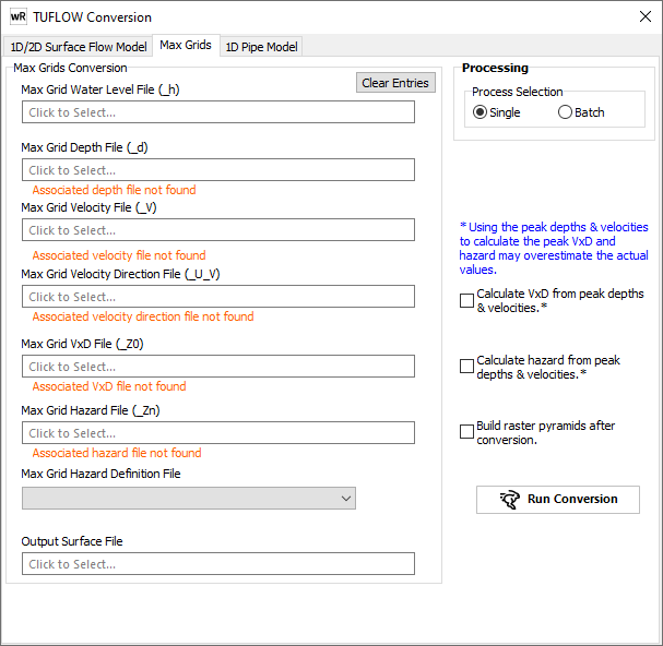
Specify the _h grid(s) (usually *_h.asc - an ASCII grid) and waterRIDE will attempt to find all other output files in the same folder with the required suffixes.
Ensure that the correct hazard category used in the modelling has been selected. waterRIDE will detect hazard files and warn if there are more than one available. If there is than one, waterRIDE will tell you which one it will use. When a hazards file is detected, the hazard definition must be the same as that used in the TUFLOW modelling. Where no hazard outputs are available, you can specify the desired hazard categories to use when calculating hazards.
If you want to use velocity vectors, you must provide the velocity direction grid file (*_U_V). Without this, velocity vectors will all point east (no angle). If this file is not available, but the model results are, you can use this guide to extract the flow direction grid from the raw results.
If some grids are not available (eg a VxD grid), there is an option to create them using other peaks grids (eg VxD = peak V x Peak D). This will produce a conservative outcome as Peak V and Peak D do not always coincide but may be useful if these files are not available.
If desired (and recommended on large grids), you can build pyramids as the grids are converted.
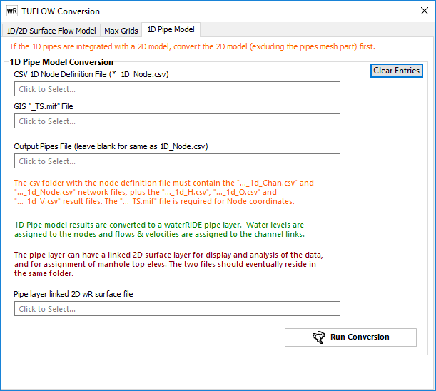
TUFLOW stores pipe flow outputs in series of CSV files. waterRIDE™ will utilise the following files in a TUFLOW pipes conversion:
•*_1D_Node.csv - the nodal definition for the pipe results
•*_1D_Chan.csv - the link definition for the pipe results
•*_1D_H.csv - nodal water levels
•*_1D_Q.csv - link flows
•*_1D_V.csv - link velocities
•*_TS.mif - GIS file containing nodal coordinates
The pipe results can be automatically linked to the 2D surface water results by specifiying the converted 2D results file to link to. An entry will be made in the cfg4 file for the Pipes layer (*.wrp), that will automatically link display the 2D water surface and pipes if they are included in the same view (the pipes layer will need to be active, with the 2D layer thematic). For example:
[METADATA]
Projection=-1
xmin=301167.96
ymin=6233782.37
xmax=304764.62
ymax=6238447.43
StartDate=0
LinkSurface=100yr_Run5.wrr