The following MIKE model results are supported:
•MIKE21 (grid and flexible mesh)
•MIKE FLOOD**
•MIKE SHE
•MIKE URBAN
•MIKE 11**
** Basic Link/Node representation of MIKE11 1D results is now available via waterRIDE FLOOD. Full TINned surface conversion must be completed in waterRIDE™ 1D Surface.
MIKE SHE must be in either *.dfs2, *.dt2/*.ct2, or *.dfsu format. If using *.dt2/*.ct2 files, it is assumed that the only time varying results in the file are Depth, Q flux and P flux. If *.dfs2 files are used, they must contain at least water surface or depth.
All MIKE results files must contain time-varying results. Conversion of peaks only results files will fail.
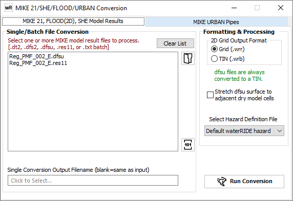
MIKE 21, MIKE 11 (Link/Node output), MIKE FLOOD & MIKE SHE Conversion
![]() Use this button to view/change the location of the DHI utility res11read.exe. Note that from waterRIDE 10.0.60, res11read.exe 2020 must be used. The latest version is available from www.waterRIDE.net/Downloads/RES11READ2020.zip
Use this button to view/change the location of the DHI utility res11read.exe. Note that from waterRIDE 10.0.60, res11read.exe 2020 must be used. The latest version is available from www.waterRIDE.net/Downloads/RES11READ2020.zip
Select the MIKE results files to convert.
If converting *.dfsu files (flexi-mesh results), there is an option to stretch the water surface from a wet element into an adjacent "dry" element if the average water surface elevation of elements surrounding the "dry" element would result in that element being wet. Occasionally, flexi-mesh results may contain such anomalies. The default option is no stretching.
If you wish to convert coupled MIKE FLOOD results (1D/2D) using the new basic link-node representation, you can:
1. Specify the res11 and dfsu/2 directly (as a single set of files)
2. use a batch text file (*.txt) containing 1D/2D pairs to convert (see batch 1D/2D conversion below)
Using one of the above approaches ensures that the 1D file is coupled to the 2D file. Coupling can be made at any time using the tool referenced previously.
For a MIKE21/FLOOD grid model, a list of result items in the file will be displayed.
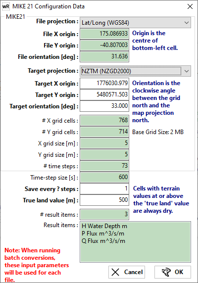
For a dfs2/dt2 results set (grid model), the user will be prompted for both the source projection, and desired output projection. *.dfs2 files normally store the source projection in Lat/Long (WGS84), with the destination being the local projection the results were modelled in. The user can enter the grid rotation angle. If the rotation is not about the lower left corner, then you should specify a rotation of 0.0 and rotate the results after they have been converted using the rotation utility.
For a dfsu results set (flexi-mesh model), the user will only see the lower third of the form, with an extra edit box to control the minimum depth threshold to apply (eg a threshold of 0.01m will only convert results where depths are greater than 10mm).
All white fields can be manually overridden by the user. Green fields are provided for reference.
The timestep size in the results is shown in the green box. By default, conversion will be for every timestep. To coarsen the converted timesteps, you can elect to convert every Xth timestep (eg double the timestep by entering save every 2 timesteps).
When converting multiple results, the timestep specified for the first result file will be applied to all files. For any 1D/2D coupled models, the timestep specified or the first 2D result file will be used.
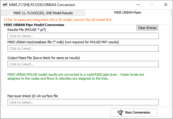
Specify the MIKE URBAN (MOUSE) *.prf output file to convert and the output file name (if desired), which will be a waterRIDE™ pipe layer (*.wrp).
If you wish to dynamically couple the pipe results to 2D surface results, the surface results should be converted first and the relevant 2D grid surface (*.wrr) specified. An entry will be made in the cfg file for the Pipes layer (*.wrp), that will automatically link display the 2D water surface and pipes if they are included in the same view (the pipes layer will need to be active, with the 2D layer thematic). For example:
[METADATA]
Projection=-1
xmin=301167.96
ymin=6233782.37
xmax=304764.62
ymax=6238447.43
StartDate=0
LinkSurface=100yr_Run3.wrr
MIKE11 Basic Link/Node Conversion
From waterRIDE FLOOD (Manager) 10.0.60 onwards, support for basic MIKE11 conversion is available inside Manager. Results will be converted to a waterRIDE Link/Node (pipe) format *.wrp, as shown below. A full TINned surface can be created using waterRIDE 1D Surface.
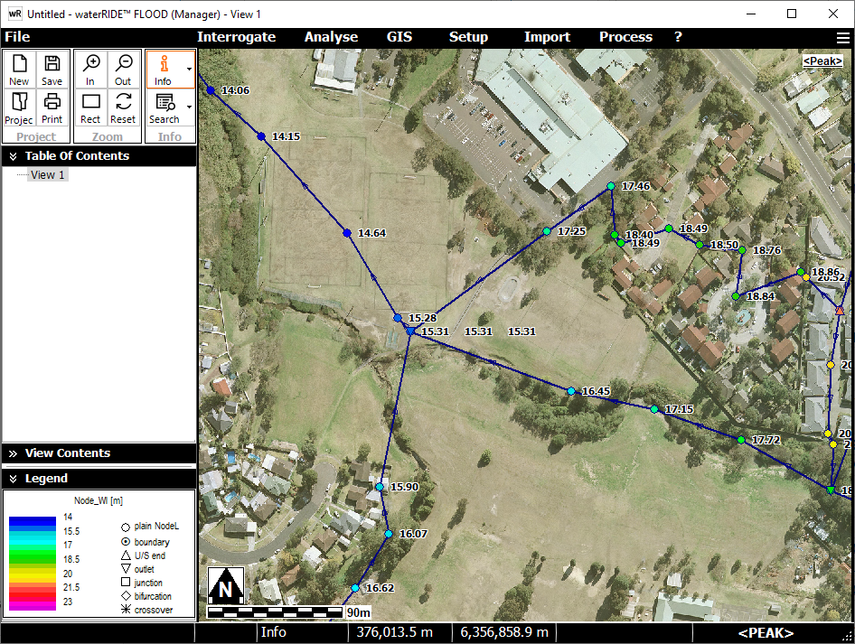
MIKE11 results store water level information at nodes (cross sections) and velocity/flow information in links (channels). To expand on the usability of 1D model results, waterRIDE will also calculate nodal values of Velocity, Depth, VxD, and Hazard. To do this, waterRIDE will use the information available in the res11 file and vector sum link information onto nodes (eg (upstream link flow + downstream link flow) / 2 = flow at a node). RES11 files store results in two ways using both standard res11 and HDadd.res11 files. If the HDadd.res11 file is not available, waterRIDE will calculate velocity using the average flow across the cross section.
Where a parameter only exists in a link (such as flow or velocity), waterRIDE will take the vector sum of the link based parameters to resolve them onto the nodes (cross sections) (eg (u/s link flow + d/s link flow) / 2 = flow at node).
Batching 1D/2D Coupled Conversion
Batch conversion of coupled 1D/2D results must be carried out using a batch file (txt). If direct conversion is used (ie adding multiple result files individually using the open file dialog), the 1D and 2D files will not be linked.
The batch file is a simple text file of the following format:
"C:\Temp\waterRIDE-RES11\waterRIDE\Pukekohe_100yrMPD_12am_8pmHDadd.res11","C:\Temp\waterRIDE-RES11\waterRIDE\Pukekohe_100yrMPD_12am_8pm.dfs2"
"C:\Temp\waterRIDE-RES11\waterRIDE\Pukekohe_200yrMPD_12am_8pmHDadd.res11","C:\Temp\waterRIDE-RES11\waterRIDE\Pukekohe_200yrMPD_12am_8pm.dfs2"
"C:\Temp\waterRIDE-RES11\waterRIDE\Pukekohe_50yrMPD_12am_8pmHDadd.res11","C:\Temp\waterRIDE-RES11\waterRIDE\Pukekohe_50yrMPD_12am_8pm.dfs2"